
File:Mediterranean Sea political map-en.svg
| |
This is a file from the Wikimedia Commons. Information from its description page there is shown below.
Commons is a freely licensed media file repository. You can help. |
Summary
| Description |
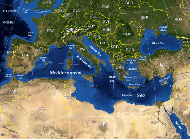
English: Map in English of the Mediterranean Sea, with the borders and the name of the States following the ISO 3166-1 Alpha-3 code.
Français : Carte en anglais de la Mer Méditerranée avec les frontières et les noms des États suivant le code ISO 3166-1 Alpha-3.
|
| Date | June 2007 |
| Source | Own work ; Raster background map : screenshot from NASA World Wind (Public Domain) |
| Author | Eric Gaba ( Sting - fr:Sting) |
| Permission ( Reusing this file) |
All rights released |
This map was improved or created by the Wikigraphists of the Graphic Lab (fr). You can propose images to clean up, improve, create or translate as well.
বাংলা | català | česky | Deutsch | Deutsch (Sie-Form) | Ελληνικά | English | Esperanto | español | suomi | français | עברית | magyar | Հայերեն | italiano | 한국어 | македонски | Bahasa Melayu | Plattdüütsch | Nederlands | occitan | polski | português | română | русский | slovenščina | svenska | татарча/tatarça | Türkçe | українська | 中文 | 中文(简体) | 中文(繁體) | Zazaki | +/−
| |
This SVG file uses embedded text that can be easily translated into your language using this automated tool. Learn more. You can also download it and translate it manually using a text editor. العربية | беларуская (тарашкевіца) | bosanski | català | česky | dansk | Deutsch | Ελληνικά | English | Esperanto | español | eesti | فارسی | suomi | français | galego | עברית | hrvatski | magyar | Հայերեն | italiano | 日本語 | ქართული | ភាសាខ្មែរ | 한국어 | lietuvių | македонски | മലയാളം | Bahasa Melayu | Plattdüütsch | Nederlands | norsk nynorsk | norsk bokmål | polski | português | русский | slovenščina | shqip | српски / srpski | svenska | ไทย | Türkçe | татарча/tatarça | українська | Tiếng Việt | Volapük | 中文 | 中文(简体) | +/- |
Licensing
 |
This image is in the public domain because it is a screenshot from NASA’s globe software World Wind using a public domain layer, such as Blue Marble, MODIS, Landsat, SRTM, USGS or GLOBE.
|
|
|
This work was previously under Public Domain, or a Free License. It has been digitally enhanced and/or modified. This derivative work has been (or is hereby) released into the public domain by its author, Sting at the French Wikipedia project. This applies worldwide. In some countries this is not legally possible; if so: |
File usage
Metadata
The best way to learn
Wikipedia for Schools was collected by SOS Children. SOS Children helps those who have nothing and no one, giving them back the famly they have lost and bringing them the very best opportunities for a happy, healthy future. Help another child by taking out a sponsorship.