
File:Nile watershed topo.png
Size of this preview: 228 × 479 pixels.
| |
This is a file from the Wikimedia Commons. Information from its description page there is shown below.
Commons is a freely licensed media file repository. You can help. |
Summary
| Description |
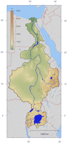
English: Course and Watershed of the Nile with topography shading and political boundaries.
Deutsch: Verlauf und Einzugsgebiet des Nils mit Reliefschattierung und Staatsgrenzen.
|
|||||
| Date | 4 January 2007 | |||||
| Source | The map has been created with the Generic Mapping Tools: http://gmt.soest.hawaii.edu/ using additional public domain data from the VMAP0 and HYDRO1K data sets. The map is in Transverse Mercator projection with central meridian at 32.5° east. | |||||
| Author | Imagico | |||||
| Permission ( Reusing this file) |
|
Licensing
|
File usage
The following pages on Schools Wikipedia link to this image (list may be incomplete):
Find out about Schools Wikipedia
Wikipedia for Schools brings Wikipedia into the classroom. SOS Children believes that a decent childhood is essential to a happy, healthy. Our community work brings families new opportunities through education, healthcare and all manner of support. We have helped children in Africa for many years - you can help too...