
File:Algeria provinces numbered2.png
Algeria_provinces_numbered2.png (308 × 427 pixels, file size: 71 KB, MIME type: image/png)
| |
This is a file from the Wikimedia Commons. Information from its description page there is shown below.
Commons is a freely licensed media file repository. You can help. |
 |
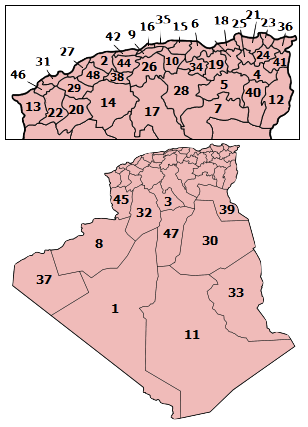
English: This map shows boundaries which are wrong or outdated. Consider using the following updated (as in 2009) map instead : File:Algeria_Wilayas-numbered.svg.
Français : Cette carte montre des frontières erronées ou qui ne sont plus à jour. Veuillez utiliser à la place la carte à jour (telle qu'en 2009) suivante : File:Algeria_Wilayas-numbered.svg.
|
 |
| Description |
Map of the provinces of Algeria, numbered in Arabic alphabetical order. |
| Date | December 2005 |
| Source | Self-made, traced from public domain UN or CIA maps. |
| Author | Originaly by User:Golbez, then en:User:Djihed, then User:Escondites |
| Permission ( Reusing this file) |
Provide attribution, please. See below. |
|

File usage
The following pages on Schools Wikipedia link to this image (list may be incomplete):
The best way to learn
SOS Children's Villages aims to make Wikipedia suitable for young learners. SOS Children's Villages helps more than 2 million people across 133 countries around the world. Have you thought about sponsoring a child?